
Oct 24, 2013
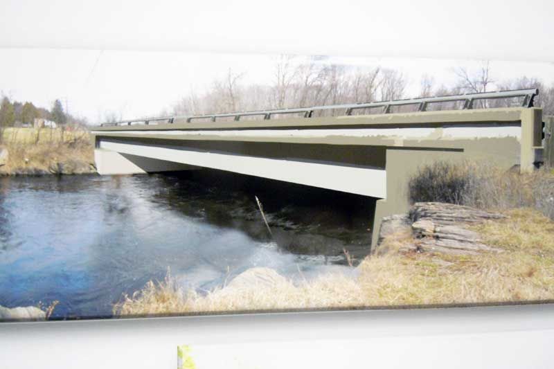
The second of three planned public input sessions on the replacement of the Salmon River bridge was held by the Ministry of Transportation and the Morrison Hershfield design firm on October 18 at the Kennebec Hall. Arden area residents had a chance to review the preliminary design and environmental assessment study of the bridge, which is located west of the intersection of Highway 7 and the Arden/Henderson roads.
The existing bridge was originally built in 1932 and was rehabilitated in 1977 and in 2004, but it has since been deemed “at the end of its service life” due to cracking in its concrete, concrete abutments, retaining walls and pavement, and corrosion in its reinforcing steel. At the information session residents perused numerous display boards and also heard a presentation by Chris Kardassis, project manager with the Ministry of Transportation for Eastern Ontario, and representatives from Morrison Hershfield Ltd., who designed the plan.

The plan highlighted three replacement options for a new bridge: A) replacing it where it currently stands; B) shifting it to the north of its current location; or C) shifting it south of its existing location. The study opted for the northern shift, option B, and cited numerous reasons for their choice. The criteria included road alignment and profile; impacts on traffic/abutting properties and the Arden/Henderson Road intersection; environmental concerns; hydrology; navigable waters; constructabilty; construction staging; and foundation concerns. Option B will see “a new concrete girder bridge on a new alignment shifted to the north as the technically preferred option”. The plan reasons that Option B will: improve foundation conditions of the bridge since the northern shift will enable more of the foundation to be built on bedrock rather than on clay silt; improve roadway geometrics and sight lines at the Arden/Henderson Road intersection on Highway 7; reduce construction time by one less stage; minimize impacts on the floodplain and existing surrounding wetlands; and minimize impacts to existing entrances and other area properties.

Construction is projected to take place over two construction seasons (two years) and is projected to start in 2015. The construction will take place in three stages. The first will include the partial removal of the existing bridge; the second is construction of the new bridge and the new highway alignment; and the final stage will involve the demolition of the remainder of the old bridge. During construction traffic will be reduced to a single lane and will be managed by temporary traffic lights. Accesses to nearby entrances will be maintained, although access to the Salmon River boat launch and picnic area will be closed. The study also included the environmental impacts and mitigation and this section forbids any in water work from taking place between March 15 and June 30. It also calls for the installation and maintenance of specific erosion control measures and the protection, maintenance and regeneration of any affected land and wetlands. Measures will be put in place to protect all affected vegetative and wildlife ecosystems, specifically nesting birds and turtles, by excluding them from the project site during their nesting seasons. Lastly, measures will also be taken to minimize the impact of the construction on the community and local emergency services.
The next steps in the planning process will be a final review and assessment of the plan, with the planning team and MTO addressing all comments received by the public. After that, the recommended plan and the Environmental Assessment Study will be finalized. A Transportation Environmental Study Report (TESR) will be completed and will be posted at three locations for the public to review. The three locations are the township offices of Central Frontenac in Sharbot Lake, and the public libraries in Arden and Mountain Grove. The TESR will be posted for one month.
More Stories
- Province clarifies stance - Says Private Well Water Testing Will Continue
- Frontenac County Stays Internal for CAO - Appoints Kevin Farrell
- Addington Highlands Tax Bill Going Up 6.93%
- Perth Road United Church Donation to The Grace Centre
- 21 Years Of Dump Life Left At South Frontenac Waste Site
- Eclipse 2024 – Once In A Lifetime
- National Tourism Week
- NeLL Spring Open House and Anniversary Concert
- 25 years at Bishop Lake Outdoor Centre
- Grounds Contracts Down, Custodial Contracts Up In Central Frontenac
